Friday, November 25, 2011

The Other Side of the World Days 5 and 6–Into the Outback

Wednesday morning started with a muggy overcast sunrise run in Cairns before our last visit to the Cairns McDonalds and the hotel buffet breakfast.  After breakfast, we bid goodbye to our Pacific International Hotel room and checked out to wait for our airport transport.  It was a bit damp and rainy for our drive, a good time for it to rain since we had no plans to be outdoors in Cairns today.

Domestic air travel in Australia is easy with the lack of ridiculousness that is American airport security measures, so we breezed through efficiently and settled into the common lounge to await our departure.  The flight was on time with no issues along the way, and after a few hours we were descending into the Ayers Rock landing strip.  Our descent offered aerial views of Uluru (aka Ayers Rock) and some of the other surrounding geological features. 

IMG_7478
Ayers Rock from the Air

As we hopped off the plane we were greeted with pleasant 80 degree temperatures, but did not expect this to last.  Some recent rains have brought the temperature down, but now that they’re out of the way, the temperature will be climbing back to the mid-90’s soon.  However, since we arrived on time to have the afternoon open and the temperatures seemed ideal, we moved our planned afternoon/evening visit to Uluru to today and quickly prepared to see the rock.

IMG_7546
Our first stop to see Uluru up close

Uluru is a monolith, a single piece of rock, about 1000 feet high with a nearly 6 mile circumference that rises out of the desert floor in the middle of nowhere essentially, which is what makes it so dramatic.  The iron content in the rock causes the surface of the rock to rust, which gives it a reddish tint that is heightened at sunrise and sunset.  Our excursion took us around different viewing posts of the rock and included some short hikes and history of the aboriginal culture here.  At the cultural center we encountered a large snake making his way down the path and were told it was a taipan, one of the most poisonous in all of Australia. We have not yet confirmed it to be true, but the snake did look impressively menacing either way as it slithered only feet away from us.  The evenings trip concluded with wine and snacks at the sunset outlook as we watched the effect of the setting sun on the rock surface. 

 DSC00164    DSC00170DSC00181    DSC00192
Uluru at sunset (photo credits:  DPH)
IMG_7598
Sunset

We returned to the resort after dark and were dropped off at the neighboring hotel for dinner, where we dined with a couple from England who were in the middle of a trip around the world.  We had crossed paths with them throughout the day, so decided to make them dinner companions.  From here, they were heading the opposite direction as us, so it was interesting to hear about where they had already visited.  Thursday was scheduled to be a very early morning since we were viewing the sunrise, so we were in bed immediately post-dinner.

At 4:35AM, our next day began and we re-boarded the same bus from the previous days’ excursion and returned to the national park.  After coffee and snacks while viewing the sunrise (on the opposite side of Uluru), we made our way another 25 miles or so into the desert to Kata Tjuta (the Olgas), another nearby geologic feature in the desert. 

IMG_7624
Uluru at just before 5 am
DSC00222    DSC00236DSC00262    DSC00270
Uluru during the sunrise (photo credits: DPH)
IMG_7647
Ulura (right) and Kata Tjuta (left, in background) at sunrise 
IMG_7684
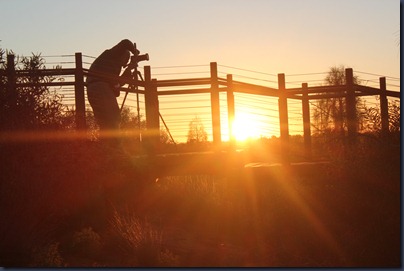
One of the many, many photographers at Uluru at sunrise

Kata Tjuta is actually a range of “mountains” that jut up to 1700 feet from the surface of the desert, but include another nearly 18,000 feet hidden below the surface of the earth.  They had valleys and gorges included, and somewhat reminded me of the area near Zion national park in Utah, but more isolated.  As with the previous excursion, we hiked a bit, visited a couple outlooks, and learned of the lore associated with the mountains before returning to the resort as the heat was rising for the day.

IMG_7728
The two geographical options for viewing
IMG_7697
Kata Tjuta up close
IMG_7724
…and far away
IMG_7726
A pictorial depiction of the multitude of flies

After a multi-hour excursion in the desert, we arrived at the hotel at only 9:15AM, so caught the end of breakfast service at the hotel before returning to the room for naps. 

The rest of the day was low-key at the Ayers Rock Resort grounds, which included a shopping complex, a series of trails to various observation points, and nice pool courtyard at the hotel.  Susan had wanted to ride a camel, so we rode the resort shuttle to the camel farm only to find it runs limited hours in the down season, and had closed earlier.  The camels were still visible in their pen, so Susan was at least able to interact with them for a bit. 

IMG_7747
Susan feeding a camel
IMG_7755    IMG_7757
Turkeys and chickens (left), camels (right)IMG_7777
A small lizard near our hotel

Evening at the resort consisted of having dinner at the Outback Pioneer Grill, which offers you the opportunity to choose your meat options from a counter where they are given to you raw.  Then you can cook your own food on the large grills nearby.  The sides, salad, and dessert were provided buffet style.  It was a fun way to mix up the dinner experience.

IMG_7784
The directions for the restaurant
IMG_7785
The meat selections
IMG_7786
Some of the cooks in our family
IMG_7790
Back home again

Tomorrow we head to another Outback post at Alice Springs for a full day of scheduled sight-seeing.   

Thursday, November 24, 2011

The Other Side of the World Day 4–Karunda and the Australian Rain Forest

Our last full day in Cairns began with a leisurely morning walk to check out a different area of downtown Cairns near the convention center.  There was not too much to write home about in this area and we soon found our way to McDonalds for our morning internet access, followed up by breakfast at the hotel.  It’s amazing how much time you have in the mornings to get prepared for the day when you are waking at 6AM or so (and going to bed by 10PM). 

Around 8:30, we regrouped with the family in the lobby to await the arrival of our transport to the SkyRail.  The SkyRail is a gondola that takes you from a small town just north of Cairns to the Karunda village, with 2 observation stops along the way.  It climbs to the peak of one of the nearby rainforest mountains for the first stop, then transverses the Barren River Gorge with a waterfall view at the second stop.  The final destination is an old mining town that is now a nature preserve and village catering to tourists known as Karunda.  While en route, we were able to spot a couple local birds and butterflies, but not much else from our perch above the rainforest.

IMG_7269
The skyrail
DSC00033
The roadway below (photo credit:  DPH)
IMG_7276
Us in the skyrail (photo credit:  Dad)

Upon arrival at Karunda, we caught a shuttle to the main drag of shops and attractions and made our way immediately to Koala Gardens, essentially a very small zoo featuring indigenous Australian animals.  It was a required stop for us in Karunda since it gave Susan (and her mom and sister) the opportunity to cuddle a koala bear.  They also let us get a family shot with Jaunita, the koala who was cuddled.  Other highlights of the gardens were freshwater crocodiles, a walkthrough reptile house, and a kangaroo and wallaby “petting zoo” and feeding pen.  They pack a lot into a small area at the Koala Garden, but it’s worth checking out if you’re looking to interact with Australian animals.  Below is a compilation of some of the animals we saw and interacted with.  Note the joey in the wallaby’s pouch.

IMG_7342    IMG_7346IMG_7351    IMG_7359 (2)IMGP4350IMG_7367    IMGP4353IMG_7385

After the Koala Gardens, we grabbed some lunch at the Rain Forest View Café, also the only spot we saw with any air conditioning in Karunda.  Susan ventured a try of a local cuisine in ordering a meat pie and found it to be quite delicious.  Then we commenced wandering the village to check out the small markets and shops.  Shopping offered the standard variety of cheesy tourist souvenirs, but also included some local crafts and aboriginal art that was impressive, albeit expensive. 

DSC00169    DSC00171
IMG_7402

Once satisfied with our shopping experience, we descended the main road back to the train station.  To get a different experience on our return trip to Cairns, we grabbed the 2PM Karunda Express train down the mountain.  This train takes the same route that was initially established to connect the mining community to the valley below and includes 15 tunnels, a variety of winding track sections and views of the Barren River Gorge from the other side as was seen on the SkyRail.  The train cars are all between 60-100 years old and are well kept to maintain their period feel.  However, the old train is also slow and quite noisy.  The trip all the way into Cairns was nearly a 2 hour journey.  I found the leisurely train ride to be a lot of fun in a quaint sort of way, but it definitely wasn’t an efficient means of travel. 

IMGP4358
Our train back to Cairns (photo credit:  Dad)

IMG_7429Stony Creek Falls (photo credit:  Jeff)
IMG_7449
Our train entering one of the many tunnels along our route

Once back in the lowlands, we returned to the hotel to relax poolside and recharge before cleaning up and heading out to dinner.  With the proximity to the Asian continent, Australia has a large selection of Asian inspired dining.  So, we chose a Chinese restaurant and enjoyed a quality dinner.

Since we bid adieu to Cairns tomorrow, the rest of the evening was organizing photographs (since we have 3 photographers in tow) and getting our luggage prepared for departure.  To be able to continue enjoying leisurely mornings, bedtime was around 10PM again. 

Tomorrow we head the the red center of Australia, into the real outback, as we visit Uluru (Ayers Rock).   

Tuesday, November 22, 2011

The Other Side of the World Day 3–Green Island and the Great Barrier Reef

Since we lost a day of our lives in transit for this vacation, so too will this blog.  Despite the fact that this is our second day in Cairns and our first full day of officially vacationing, I consider it the third day of the trip (our itinerary calls it day 4…confused yet?  So am I).

Due to the travel/time-zone induced exhaustion, the previous night’s bedtime was around 8PM local time, so day 3 began early.  I awoke after 9+ hours of sleep at 5:15.  It was not only early, but also bright since the sun begins rising in the early hours as well.  To take advantage of the sunlight, I went for a jog along the esplanade (boardwalk).  Cairns has a fair bit of coast line and have built a boardwalk path that spans 5k+ through an area of shops as well as a park and some beach shore.  Because of this, I was able to stay along the shore for the entire out and back run…and I was not the only one.  It was the most pedestrian traffic I had seen pre-7AM anywhere.  Mostly there were people walking in groups, but there were other runners (and occasional cyclists on the adjacent path) as well as others just enjoying an early morning in the park.  I thoroughly enjoyed the activity, especially after being cramped in travel for the past few days.

Returning to the hotel, I found Susan had awakened early as well, so I cleaned up and we headed to the local McDonald’s to take advantage of the free wireless internet, which seems to be a rare commodity.  I normally avoid anything familiar while on vacation (and McDonald’s in general for that matter), but the free internet makes the arches look might appealing for morning coffee trips during this vacation.  We attempted to order coffee, though not really understanding the language of java around here yet (options include long black, flat, short white, etc…) made it more difficult, then got our online errands completed.

After McD’s it was back to the hotel to have the breakfast buffet and regroup with the family for the walk to the marina.  Today’s planned activity was a boat trip to Green Island, a protected coral island that is actually a part of the Great Barrier Reef.  Part of the island has a resort built on it, although done tastefully to not take away from the natural lushness of the island rainforest.  The other portion is a small national park.  Surrounding the island is a portion of the barrier reef.  At the marina, we selected a few of the scheduled activities for the island and got our boarding passes before stepping foot onto the Reef Rocket for our 45 minute ride to
the island.

IMGP4317
The reef rockest
IMGP4259
Ready to snorkle.. almost

Upon arrival, we headed into the resort area quickly, then made our way to the beach and donned the snorkel gear.  Included with our snorkel, mask, and fins was a pretty awesome lycra body suit called a stinger suit.  Apparently stinger is the local name for jellyfish.   Although we weren’t terribly worried about stingers since stings are rare at Green Island, we wanted the suits for their sun protection along with their obvious style.  Snorkeling could be done on multiple beaches of the island, but we selected the one recommended by our boat guides and waded into the ocean.  Susan, always the photographer, donned a disposable waterproof camera, so we have some solid photos of our findings.  We were able to develop and then take pictures of the pictures, so the quality of these pictures isn’t great but you get the idea.  Among the highlights was a variety of colorful corals and fish, sea cucumbers, and a few sea turtles that evaded me, but Susan managed to spot multiple times and almost lured close enough to touch once.  The variety and size of the fish encountered, particularly so close to the shore was impressive. 

IMG_7251
Susan’s best friend, the sea turtle (note there is no zoom on an underwater camera  --  he was just that close)
IMG_7257
Us in our stinger suits
IMG_7260
Some of the coral at the Great Barrier Reef
IMG_7263
A fish staring at us

Our snorkeling was ended when it was time to board the semi-submarine (a boat with an underwater viewing chamber below) for a scheduled tour.  The loop here was brief, but informative with a good guide and a variety of larger fish we hadn’t encountered previously.  It also included a fish feeding that drew out additional species (but no sharks).

IMGP4298
A sampling of what we could see out of the semi-sub
DSC00077
In the semi-sub

The remainder of the day at Green Island included lunch, walking the nature trail through the national park, exploring what we could see of the resort, and playing on the beach a bit.  A leisurely paced cruise back to Cairns brought us ashore around 5PM, worn out from the day in the sun.

After some much needed clean-up and recharging at the hotel.  Susan and I ventured out for our own dinner date.  After wandering the main drag some, we felt Indian calling to us…or so we thought as we selected the restaurant.  We had been discussing wanting to experience some foods more in line with Australian tastes, or something more exotic than we could get at home.  Turns out, the Indian restaurant offered a tasting plate of 3 native Australian animals (kangaroo, crocodile, and emu), and although we know Australians don’t actually eat these animals regularly if at all…we decided to split the tasting plate along with some naan, of course.

IMG_7241           IMG_7246 - Copy
On the plate:  kangaroo (top), crocodile (yellow), emu (bottom)
Susan and I with our Aussie meat (right picture)

The meal was a little odd considering it was a meat plate and some bread, but it worked for us.  All the meats were a little dry and chewy, which either speaks to the consistency of the meat or the quality of the cooking.  Emu was probably my favorite since it seemed to have a higher level of fattiness than the others.  Either way, I can see why none of these animals are farmed for meat like chickens, cows, etc…

Post dinner, we did a little light shopping in the area near the Night Market, which is an indoor “mall” of vendor booths that’s open from 4-11PM daily.  The shops in the general area keep longer hours as well, so the scene was pretty busy as we checked out the wares, some of which were quite…unique.  As we shopped we worked our way back to the hotel for another early night.

Tomorrow we head inland to check out the rainforest, and (Susan can) hopefully cuddle with koalas.

Sunday, November 20, 2011

The Other Side of the World–Australia/New Zealand Vacation Prelude

After a few months of saving as much vacation time as I could muster (not quite enough), we left Friday morning for a 2-week international adventure to the Southern Hemisphere.  In the next couple weeks we will be making a tour of as much as we can cover between Australia and New Zealand.  Hopefully, if we’re not too busy or exhausted, Susan and I will be able provide a comprehensive and well-photographed report of our daily highlights.

Since we’re travelling with Susan’s family, who is based out of northwest Ohio, it was most convenient and cost effective for us to fly from Detroit to begin our journey.  Thus our first travel morning started bright and pre-dawn on Friday with a drive from Cincy to Delphos and then on to Detroit.  From there we fly to Chicago, then to LA.  Just before midnight Friday (local LA time), we departed for Brisbane (a 14-hour flight).  Magically, we crossed the international date line and Saturday ceased to exist, so we landed in Brisbane on Sunday morning.  However, the fun doesn’t stop there as we had one more short flight up the coast to Cairns (pronounced “canes”) where the vacation really begins.  All told, transit took 41 hours of actual travel time including both flights, layovers, and driving, but covered ~55 hours of time considering the time zone shifts.  Despite the tedious travel involved, we were very excited to make our first trip down under and couldn’t wait for the real vacation to begin.

IMG_7153
Sailing through the clouds (Detroit –> Chicago)
IMG_7160    IMG_7163
Lake Michigan melding into the sky (left)
Sunset over Los Angeles (right)
IMG_7167
The flowing coast of Brisbane, Australia
IMG_7170
On the fourth airplane of the weekend
IMG_7182
The landscape of Cairns, Australia

We arrived exhausted and ragged in Cairns around noon on Sunday, with an afternoon ahead of us to see the town.  After a meeting with our local guide, we headed to whatever meal is at 4 pm after being awake for 12 hours (and our bodies thinking it is 1 am).  We then took a stroll down the boardwalk, did some people watching at the lagoon, and checked out the Night Market.  Once we picked up some beer and water, we played cards and tried to stay awake as long as possible so to attempt to adjust to the 15 hour time difference between Ohio and Cairns.  Shockingly, not as difficult as one might think.  In our zombie-like, sleep-deprived stupor, Susan and our brother-in-law Darin (who does this photo stuff professionally; aka DPH) were able to get some great photos. 

IMG_7194
View from our hotel room, looking toward the ocean
DSC00009
View from our hotel room, looking toward the bay (photo credit: DPH) 
DSC00013
Our 50’s style room with beds on wheels (photo credit: DPH)  
DSC00041
Aussie Money
 (photo credit: DPH)
IMG_7205

Bird chilling in the bay
DSC00011
Susan doing her thing (obviously.. photo credit: DPH)
IMG_7218
People swimming in the lagoon in the hot Cairns sun

Our local guide let us in on a secret that while internet in our hotel room would cost $11/hour, the McDonald’s down the street offers free internet.  So even half-way across the world, we’ll be making some trips to Mickey D’s to post our blog/get out internet fix.  Tomorrow brings a full day of sightseeing at the Great Barrier Reef!

Wednesday, November 16, 2011

A Busy Fall Part 3: Rock n Roll St. Louis Marathon

After a couple weekends with more laid back endurance activities in the books, it was time to close out the 2011 season with my last A race, the inaugural Rock n Roll St. Louis Marathon.  Despite this being my second A race of the season, it has clearly been the focal point of my training…so maybe it’s my A+ race.  Having not done an open marathon since 2008 and having bad memories of blowing up at the wall in my previous 2 attempts in Arizona and DC, the marathon has been a race that I have learned to respect.  My main goal going into the race was to not break down and run a consistently paced race…no specific time goal.  Here’s how the weekend went…

The wife and I arrived in St. Louis Friday evening to stay at my sister and her fiancé’s place.  They, along with my dad, would once again also be participants in the same event.  “The family that races together, stays together” would be an apt motto for our family.  We made a point of getting into town early in the evening since we were going to be taken to our first (for Susan and me) NHL game.  The Blues game was exciting and our upper deck location made it easy to follow the action.  To add to the excitement, the Blues pulled the game out in overtime before having to go to a shootout.  After the game, the rest of Friday evening was quiet as we settled in.

IMG_6684Blues Game

Another reason we had planned on arriving in St. Louis Friday was to have Saturday morning open for Susan to take some engagement photos for Kelley and Jason.  They got off to an early start with a variety of outfits and locations to shoot in mind.  This was Susan’s first try at engagement photography and the results were successful.  I did not tag along with the photo shoot and instead made my way to Carondelet Park for a very short run on the southernmost portion of Sunday’s marathon course.  After the run, I waited for my parents to arrive from Louisville and the three of us made our way to packet pickup.  Earlier in the day, the crowds weren’t too bad so we progressed through the pickup and expo quickly.  After getting back to our home-base for the weekend, we awaited the arrival of the photography team before grabbing a late lunch.  The rest of the afternoon involved spectating at Jason’s kickball game briefly before relaxing at the house for a bit.  With it being the midst of World Series madness with the Cardinals in the mix, our pre-race dinner was watching the game with a couple hundred other rabid fans at the Sports Zone (a local sports bar).  The energy was awesome and the game was pretty wild too.  However, I was concerned about being ready for Sunday’s race, so I cut out early after dinner and returned to the house to get my gear in order and head to bed.

Sample Engagement Picture Awesomeness

Sunday started off bright and early (or dark and early in actuality), as is usually the case for race mornings.  We grabbed our gear and headed downtown to the starting area to wait nervously and make our way through the pre-race rituals.  Weather was looking pretty perfect as dawn came, starting temperatures around 50 with overcast skies but low threat of rain and low humidity.  The temperature would remain mild until mid-afternoon when the clouds cleared, so the weather could not have been much better for the duration of the race.  After dancing nervously and calling it a warm-up, stripping down to my race outfit, and kissing the wife good-bye I headed into the corral with the other sheep…I mean runners.  Not too much later (in reality, not in perception) the gun was fired and we were off.

IMG_7090

Being in the first corral, I was pretty close to the starting mat and near the front of the swarm of runners.  There was still a fair amount of navigation to take care of though as we sorted ourselves out and claimed a position.  My main focus other than finding space was to not go out too fast, so I checked my Garmin relatively regularly through the initial miles to make sure I was at a sustainable (or slightly slower than) pace.  By mile 3, we had begun to string out enough that the roads seemed more open.  We made our way up Washington Ave in this section and away from downtown toward St Louis University’s campus.  The section between downtown and SLU didn’t offer much in the way of scenery or spectators, but it was early enough that outside motivation wasn’t really necessary.  As we turned to pass the historic Fox Theatre, the crowd returned in full force.  There was even a group from the local Y who had fashioned a star-shaped arch of balloons for runners to pass through, so I obliged.  From here, we moved past the SLU chapel and around the back of campus before turning south.  So far, pacing was nice and steady between 7:25-7:35 for each mile.

After passing through the bold colored signs of bars in restaurant in an obviously gay community, the course began the tour of the South St. Louis parks.  First on the list was Tower Grove Park.  This was our first encounter with the park and around the 8 mile mark of the overall course.  Also notable was that the marathoners and half-marathoners made the split at this point.  As we divided to go our separate ways, I was amazed to see the imbalance between full and half participants.  There were a huge number of half-marathoners, outnumbering the full runners at nearly a 10:1 ratio.  Needless to say, as I turned with the handful of other marathoners to take the long way home, I was feeling a little lonely.  It was time for the real race to begin.

The park tour continued, passing Sublette, Tilles, Lindenwood, and Willmore Park’s (each complete with their own band) as we continued to head away from the finish line.  I hit the halfway point and was still feeling strong.  There was stiffness popping up occasionally, but I felt in control and continued to down gels every 5 miles as I plodded along at just under 7:30 pace.  The surroundings became more familiar as I entered Carondelet Park, where I had scouted the course the day prior.  I had a boost of energy knowing every step from here was in the direction of downtown and the finish.  Leaving the park, I had covered around 16.5 miles and was not running with much company anymore.  To provide myself some additional mid-to-late race motivation, I saved my iPod for just this moment.  Wandering into my own tunes with less than 10 miles to go felt great, and I picked up the pace just slightly.

En route back to downtown, the route took us past Bevo Mill Restaurant (sp?) right around the time we hit the 20 mile mark.  This was a good point for me to see where I stood.  I certainly wasn’t 100%, but I was moving along steadily and could not see myself crashing in the near future.  The course did not make it easy on us though, as mile 20 was nearly all uphill on a straight grind from the restaurant until we re-encountered Tower Grove Park.  I felt good as I ran beside the park…I was past the 20mile mental barrier and on flat roads for now.  I had the confidence that I was going to finish strong.  However, at this point, my legs were pretty worn down, so picking up the pace was not an option.  The goal became to maintain the pace to the finish.

As I exited the Tower Grove Park area, I got another morale boost as the course re-merged with the half-marathon course which was now filled with the half walking crowd.  It was a large crowd and I was again amazed at the number of half participants.  Luckily, the roads were wide and they created a separate lane for full marathoners so I didn’t have to navigate traffic.  As I passed the mass of walkers, many of them yelled encouragement to the marathoners as we went.  Plus, now there were a bunch of witnesses if I decided I needed to walk, so it provided quite a bit of motivation.  The half-marathoners would accompany me the remainder of the way to the finish.

As I hit mile 23 near Lafayette Park I was pleased since I felt like I had a solid race in the bag.  But 3+ miles still seems like quite a drag so I was ready to be in the finish chute.  I kind of went into a trance in this section where I didn’t feel good or particularly motivated, but I didn’t need to stop and was close enough that I wouldn’t have anyways.  I just had to get the work done at this point.  The roads opened up around mile 25 and I could see Union Station off in the distance.  The finish was at the park just on the other side of the station.  It seemed to take longer to cover the distance until Union Station was passing on my right, but by the time I reached it I could hear the finish line hoopla, so put away my iPod and prepared to take in the finish experience.  A female runner that had been near me for the last mile or so got news from a spectator that she was 5th (if I remember correctly) woman on the road as we rounded the last bend into the home stretch.  I eased up a bit and let her kick ahead to have plenty of time to enjoy her impressive finish, then I cruised in shortly behind with a smile on my face (a rarity for me at the end of races, although I’m sure it looked more like a grimace).  I stopped the clock, officially at 3:15:50 which to my surprise was a top-100 overall finish.

[IMG_7133%255B6%255D.jpg]Not my best look, but victorious nonetheless

I cheerfully made my way through the finisher’s chute and waited in line to grab some nutrition.  All of a sudden my legs realized what had happened in the past few hours because I was overcome with throbbing pain from my glutes all the way to the bottoms of my feet.  It was pretty excruciating, so I wasn’t in such a good mood anymore.  I continued out to find my family moving at a snail’s pace now, before settling down on a stone barrier to rest/stretch.  It took a good 10 minutes for the pain to subside and I could attempt real movement again, but by the time we moved back to the stretch to watch our other runners finish I felt pretty decent, and incredibly tired.  The three remaining runners decided to do the whole event together and crossed the finish within a minute of each other.  What makes it more impressive is that Jason, my sister’s fiancé, had not done a marathon before and was actually registered for the half…he just “felt pretty good” at mile 8 and decided to attempt the full.  My dad and sister also both PR’d after doing some solid sandbagging when talking about the race in the weeks leading up to it.

It was a great way to end the 2011 season and I’ve finally conquered my marathon demons, so have a high level of confidence heading into the 2012 season.  But first, off-season, vacation, and the holidays…and did I mention a vacation.

Monday, November 14, 2011

A Busy Fall Part 2: Hilly Hundred Weekend 2011

My October of activity continued with the Hilly Hundred Cycling Weekend in Ellettsville, IN a couple weeks ago.  It is a laid back cycling tour through south central Indiana, near Bloomington.  About 5000 cyclists of all ability levels come and take on the course with its varied, rolling-hill terrain for a couple days, riding a little over 100 miles (and 8000+ ft elevation gain) total.  I have wanted to do a lower intensity, “enjoy the scenery” type of fall tour for some time now and finally got a chance thanks to my sister and her fiancée having previous experience with this event (and also participating this year).  Here’s how the weekend unfolded…

Friday evening, the wife and I packed up and made our way to Ellettsville.  The drive from Cincy took us longer than anticipated since much of the trip is on back roads.  We also had not anticipated the driving time to and from our hotel to race registration and back, which added almost an additional hour.  Either way, we made it to registration at the local high school and found the school grounds had been invaded by an army of tents and RV’s.  Apparently a large percentage of participants come for a weekend long campout as well…an idea that I think would be appealing when participating in this event in the future.  Registration itself was pretty straightforward and included a fun welcome video (featuring Peewee Herman).  Susan grabbed her volunteer information as well since she would be working an aid station on Saturday morning, then we made our way back to to find my sister and company and eat a late dinner before relaxing at the hotel for the night.

Saturday began early, sometime around 5:30am with breakfast at the hotel and driving to the high school (also the start and finish for both Saturday and Sunday rides) to ensure Susan arrived in time to man her aid station.  I took the extra morning time to clean my bike a bit and grab some coffee to get myself warm since the dawn temperature was in the mid-30s.  Once we had collected our group of riders, we took off on day 1’s voyage in the 7:00 hour.  With this event, there is not a set start time…you just take off whenever within a range of morning hours.  This works pretty well with the incredible amount of bikes on the road.

Ride 1 – 57.5 miles – 5200 ft ascent
A caravan of cyclists exited Ellettsville with us, so the pace was exceedingly slow at the start as we weaved through traffic to find some room to maneuver.  A short, but very steep climb came right out of the gate which didn’t help the traffic situation since some bikers were walking their gear up the hill and others were resting waiting for friends to catch up at the top.  Our group bypassed this hill and found the roads more open on the other side.  About ½ ways between the start and our first rest stop (only about 15 miles in) I pulled ahead of our group to attempt to get my heart rate up some and loosen my legs up.  This was mostly an effort to warm my body up, and it seemed to work pretty well.  I pulled into the first aid station a couple minutes ahead of the rest of our party and went to search for the wife.  I found her incredibly busy at the food tent slicing muffins and bananas.  It was amazing the activity of participants loading up on the offerings of snacks after only 14 miles of riding.  The amount and selection of food was pretty astounding including donuts (the pumpkin was popular), muffins, granola bars, fruit, bagels and peanut butter, etc.  The placement of rest stops worked well for our group throughout the weekend since we could ride at our separate paces and regroup periodically to ensure we were all relatively near one another.

At Rest Stop 1

Once regrouped and successfully sated, we moved along toward the lunch stop.  That’s right, more food only 14 miles ahead.  This section was pretty flat compared to what was ahead, but included some rough pavement so the ride was taxing at times.  Through this segment of the ride the temperatures came up and it was time to strip the over-layers I left with in the morning.  By the time we reach the lunch stop, it was comfortably warm and sunny.  Lunch included another smorgasbord of food including fried chicken, pasta salads, veggies, cookies and ice cream treats.  I was amazed I was able to resist over-filling myself, but the thought of riding bikes on a full stomach made many of the options less appealing.

Either way, by late morning we left for the second half of the day’s ride.  In the first couple miles after the lunch stop we passed a long elevated train bridge across the fields to the left.  A lot of riders stopped for a photo op as it was quite picturesque.  Unfortunately my camera batteries died within 15 minutes of starting the day’s ride, so I just had to take a mental snapshot as I rode by.  The next section of road was marked by a number of rollers, but no major climbs.  However, the roads in this section were some of the sketchiest we would encounter through the weekend.  Considering the variation in rider handling skills and the number of cyclists on the road, I thought this section of the route in particular was a questionable decision by the race organizers.  I consider myself a competent bike handler, but was white knuckled on a couple of the descents with blind corners and hard to spot pot holes and gravel.  Another rider nearly crashed just behind me when he launched a water bottle on a pot-holed descent and the projectile got lodged under his rear-tire.  Amazingly he recovered and we all shared some nervous laughter recounting the experience, but obviously it could have been a potential disastrous situation.  A secondary effect of the rough roads was premature discomfort in the saddle.  As we neared the last rest stop of the day I was ready for a break to stretch out.  I noticed a cyclist pass me with a kit that reminded me of my high school, so I let him pace me to the next stop where I could ask him about it.  Turns out, it’s the official racing kit of the Trinity High School cycling club team that apparently was started a couple years after I graduated.  I talked with my new acquaintance and admired his kit while waiting to regroup at the last station.  With only about 12 miles remaining in the day, I bypassed the food and just reloaded on water before leaving for the final miles of the day.

The last stretch into town was the toughest of the day.  The road conditions improved, but the rolling terrain seemed to compress into a constant series of ups and downs.  Also complicating the final stretch was the increase in traffic near and in Ellettsville.  None of the roads were closed to traffic, which wasn’t really an issue on the isolated country roads.  However, in the city even though traffic was light by most standards, every car on the road with the multitude of bikers made navigation difficult.  Midway through this stretch I was ready to be done with the Saturday ride, so I pushed a little harder and just knocked out the remaining miles.  I reached the finish area and just lay on the ground at the high school until everyone else arrived.  Once all were collected I tracked down the wife who was exhausted from her volunteering experience (but said it was a lot of fun interacting with the riders, locals, and listening to the rest stop band belt out jazz tunes) and napping in the car.

After the ride, it was back to the hotel for cleanup, college football, and naps before heading into nearby Bloomington for dinner.  Being a college town, Bloomington offered a good selection of “pub grub” which is exactly what we were craving after the day’s exertion.  It was at dinner we all realized that even though we weren’t pushing the paces too hard, the effort of the day had taken a toll on us…we were tired.  The remainder of the evening was spent at the hotel with beer and board games before an early bedtime.  The Sunday route awaited us early the next morning.

With no volunteering to hurry down for, Sunday began slightly later than Saturday and the extra sleep was appreciated.  Also, the morning weather was warmer so less layering was required.  The temperatures by the end of the ride Sunday would actually be in the mid 70’s.  Since we’d also be driving home at the end of the ride today, we started just after dawn.

Ride 2 – 49 miles – 3950 ft ascent
Sunday’s route left town in the opposite direction and is apparently the same route every year.  It contained most of the notable hills and sites of the weekend.  That being said, the first 9 miles to the rest stop are kind of slow and unremarkable.  There was a nice stretch in a valley between fields of crops surrounded by rolling hills that was a pleasant way to warm up the legs while taking in some nice scenery.  It was actually more ideal to start with a segment that included less major hills at the start of the day to get some miles knocked out while making sure everything was in order.  Since we were somewhat more concerned about making good time, we only stopped long enough for a quick stretch before leaving rest stop 1 and heading toward the lunch stop.

Heading Out of Town to Start Day 2

The second segment of the Sunday route was the highlight for me.  Initially you cruise through some farm roads before making way into a more heavily wooded area.  Much of this section is a state forest, explaining all the trees.  Before long, you officially enter a state park area where the roads are in perfect, smooth condition.  After a couple miles enjoying the roads and forest, you will hit one of the signature climbs of the Hilly, Bean Blossom Hill.  It’s the longest total climbing section of the whole route.  The base of the hill is steep and gets you cranking and worn out right away.  After only about a quarter mile or so of hammering the steep segment, Bean Blossom relents into a false flat before essentially stair-stepping for the next 1.5 miles or so.  The reward at the top is even smoother roads and a long gentle descent out the other side of the park, complete with some openings in the tree line to some spectacular forest views from above.  I was in my zone through here and probably experiencing “cyclers high”.  The weather had warmed up a good deal and I would have been uncomfortable with my windbreaker, but the shade kept the park nice and cool.  As you exit the park proper, you pick up the descending pace, and basically just coast right in at a high speed to the lunch stop.

A Taste of the Local Scenery

With the wife off-duty for Sunday, she made her way around with camera in tow and met us for lunch.  She was also doing a bit of artsy photography with my sister and her fiancée’s bikes for their upcoming wedding, so was on her photography game.  As the rest of the group arrived we grabbed food (same offerings at all the stops as the prior day) and lounged for a while on the grass, baking in the fall sunshine.  Pressed by our tentative schedule, we didn’t picnic for too long before heading onward.  The Mt Tabor climb stood between us and the next rest stop and I was eager to see what the deal was.  Over the past couple days since arriving in Ellettsville; I’d heard many participants allude to it in anticipation or dread.

Right after leaving the lunch venue, there were a couple climbs that were no joke, there to punish those who overindulged on cookies and ice cream.  After overcoming those climbs in the initial miles, things flattened out.  However, the pace didn’t rise since the road conditions deteriorated some as we cruised through open farm fields with grazing livestock.  Also, now that we were in open air and atop a hill I was able to notice how windy it had become.  For the most part there weren’t crazy gusts, but just a steady strong breeze.  At this point, I had enough energy to just push through it when it was working against me.  Before long, we got shielded by trees as we descended into the valley just before Tabor.  Now, Mt Tabor isn’t a mountain at all as there are none in the area…it’s not even really a very tall hill.  The segment of road that climbs Tabor is less than a quarter mile long.  What makes Tabor the epic climb of the event is that it takes the quickest way possible up the hill, making it consistently, impressively steep.  The average grade for .2 miles is 20.2%.  Many participants were unable to even attempt climbing that grade and instead opted to walk it from the beginning.  Further complicating the Mt Tabor climb is the traffic that gets built up there…people walking…people passing…automobile traffic.  At any moment the person struggling in front of you could tumble causing a massive slow speed pile-up.  Then, if that’s not enough, there is an intersection at the top and the grading increases to greater than 23% at the very end to accommodate the incoming road.  If out riding solo, I don’t think I would have too much trouble with it, but I nearly did not make it after getting stuck behind someone moving much slower than me due to getting pinned to the right by a truck coming down the hill.  Luckily, before I came to a complete stop, the truck passed and I was able to swing into open space and make it to the top.

 Participants Struggle Up Tabor (I’m not longer one of them at this point) 

Many people congregate at the apex of Mt Tabor to celebrate their accomplishment, but I decided to move along since the final rest stop was only a couple miles ahead on downhill roads.  Unfortunately I missed Susan who visited Tabor to take in the suffering with her camera lens and the rest of our party met her at the top for a break.  Before the last rest stop in a small town there is a very fun winding descent into the town center.  It had some technical turns, so had some hay bales setup.  This gave the arrival into the last rest stop a very European cycling race feel…very cool.

The last rest stop was also a highlight since it had a great back-country band playing very folksy tunes like “Home-grown Tomatoes” and including banjo and spoon players.  Everyone regrouped one last time and enjoyed the music before moving onward.  My sister and I went ahead since we were getting warm and ready to complete the ride.  The last miles had one notable climb to the Ellettsville town water tower, but was more notable for the wind.  A head and cross wind made it a slow grind for 2/3’s of the last segment.  My sister and I just settled into a cadence and talked as we worked through the wind.  No reason to overdo it now.  After climbing to the water tower, though the descent put us in line with the wind and the tailwind propelled me home to the finish.  The Hilly Hundred 2011 was complete!

Looking back, the event was a blast.  I would highly recommend it, or other fall bike tours like it.  It’s a much different atmosphere from the road running and triathlon scene with a different crowd.  The bike tour crowd is a laid back bunch, eating a lot, enjoying the scenery, talking it up with anyone and everyone.  Also, at least in the case of Hilly, they’ve found a way to coexist with the locals despite overcrowding the roads.  Many locals allow their yards and towns to be hosting sites for rest stops and are out enjoying the music and interacting with the riders.  If I return in the future, the only change I would make is look closer into camping at the high school.  It would have been nice to be closer to the starting line and I think camping (assuming good weather) would add another element of fun to the event.

As I continue to clear up the backlog of posts I need to get out, my next task is to get a race report for the St Louis Marathon written up and on the blog in the next couple days…before it gets overshadowed by the upcoming vacation!